
We feel farming as a work of tender love, and we need to share a story, full of grief and praise, about this place.
We farm in the floodplain of two runs, twin runs of the South Fork of the Shenandoah.

We farm in the floodplain of Blacks Run, a name possibly originating in the tanning industries that leached dark water into its flow that goes through our backyard nursery beds and groves in Harrisonburg. In numerous places Blacks Run has been forced underground, like a fugitive in its own home, a hydrological version of house arrest. Its natural flooding has turned into a traumatic reaction to this concrete claustrophobia, spilling out of its bed more than its share of sediment, nutrients, and chemicals. And yet the stream still supports snapping turtles, community cleaning efforts, Mulberry, Willow, and Walnut, which we tap for the sweet sap and harvest the rich nuts.
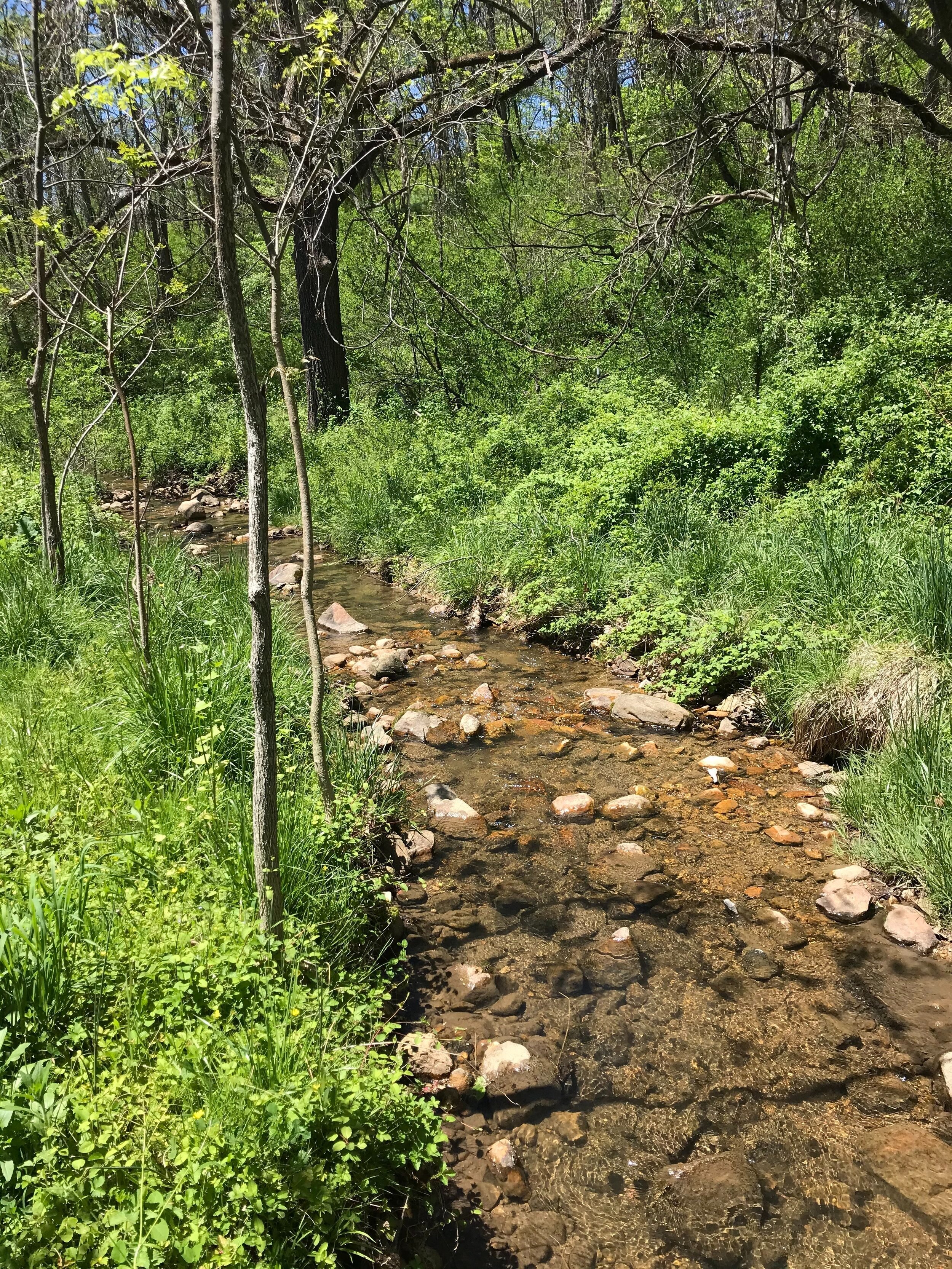
We also farm in the floodplain of Cub Run, a rural water-vine twisting down its stony green bed from Massanutten Mountain, its folds formed by the rumble and shudder of geologic growing pains, its ridges peopled by Black Bear, Deer, Turkey, Coyote, Rattlesnake, and Mayapple, Chestnut Oak, Spicebush, Mountain Laurel, Pine, and endless mycelia stitching them all together. Cub Run weaves together tangles of quick creeks growing Walnut, Sycamore, and Elm. Spring and rainwater descend together through Keezletown, a small village patchwork of old farms, residential roads, and a public school-turned-private that once hosted a community cannery. Both Blacks Run and Cub Run are marginal and fertile places.
Our stretch of urban stream runs through a neighborhood flanked by poultry factories and the Northeast Neighborhood, the historic segregated area that began as a township of free people of color and escapees of enslavement. Originally called Newtown, Harrisonburg absorbed it around 1892. In the 1960s, the city government used federal redevelopment funds in an effort called Project R4 to dismantle a large portion of the neighborhood, forcing Black families to sell their homes through eminent domain and bulldozing the neighborhood in the name of urban renewal. To accomplish this, the city planning office declared the Black community a slum. And yet it is still home to most of Harrisonburg’s predominantly Black churches and the Lucy Simms Continuing Education Center, the historic schoolhouse for Black students during segregation. Some community members are calling for a Truth and Reconciliation Commission to hold the City accountable and heal these wounds.
Route 11 passes between Blacks Run and the Northeast Neighborhood. That road was once called the Valley Turnpike, or the Great Wagon Road, and it was part of the thousand-mile-long passageway for the Slave Trail of Tears: a forced migration that deported nearly one million enslaved people, over a fifty year period, from the Tobacco South of Virginia, Maryland, and Kentucky, to the Cotton South of Louisiana, Mississippi, and Alabama. Shenandoah was wheat country when this chained caravan came through. One-fifth of the region’s farmers were enslaved Africans. Before 1900, the Slave Trail of Tears was the largest and longest movement of people in the history of North America.
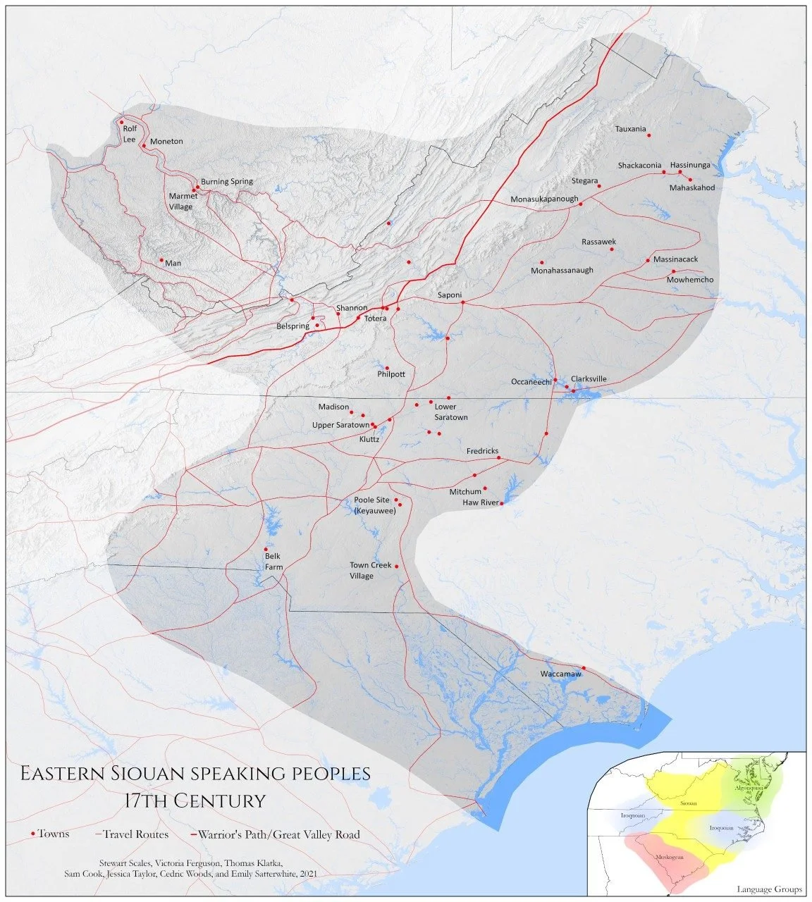
Our stretch of rural stream runs parallel for a spell to Indian Trail Road, so named for the extensive travel and trading route through the Valley established by Indigenous nations of the Yesa, or “the People,” the Siouan speaking alliance of the region. European settlers coopted many of the roads, along with village sites and farm fields, emptied by pandemics and genocidal campaigns, both formal and informal, that displaced and killed millions of Native people across Turtle Island.
Keezletown is seven miles south of the historic community of Zenda, formed by emancipated enslaved people at the end of the Civil War. Rockingham County officials took the property from an enslaving plantation owner after the war and sold it to the free people. The people called their home Little Africa. Zenda circled around Long’s Chapel, named for a white landowner who opposed slavery and supported the effort to build a church for emancipated people. The chapel grounds became the church, the school, and cemetery for the Black community in the midst of segregation. Lucy Simms began her teaching career at Zenda’s school. When it closed in 1925, she and many students transferred to the Effinger Street School in Harrisonburg, which ran for almost 60 years before the building was condemned and replaced by the structure that now bears the teacher’s name. At its height, Zenda was home to 17 households of 80 people with a general store and post office. The village was mostly empty by 1930. Official history says that residents had either died or relocated to Harrisonburg and elsewhere. In 2005, Alfred and Robin Jenkins bought the church to restore it and establish a Black history heritage site. Long’s Chapel and its limestone cemetery still stand in honor of Zenda’s memory and are on the National Register of Historic Place.
The city of Harrisonburg, within Rockingham County, now has a population of about 50,000 people, 25% of whom live below the poverty line, a percentage over twice the state average, and almost 80% are white. Almost 2,000 refugees have settled in Harrisonburg since 2002, with 55 languages spoken in the public schools. The community of Keezletown is unincorporated but once Harrisonburg’s main competitor to be Rockingham’s county seat. George Keisell liked the prime location off Old Indian Trail and saw it as a rival to Harrisonburg’s Great Wagon Road. Local legend says a Keezletown representative, maybe Keisell himself, and a Harrisonburg representative, maybe Thomas Harrison himself, raced on horseback to the state capital in Williamsburg to legalize their towns as the premiere place to be. But the Keezletown rep’s ride broke down on the side of the road with a lame foot. Other versions say he stopped off at a tavern and had one too many drinks.
Harrisonburg and Keezletown are in the Shenandoah Valley, a basin of ridges and valleys within the Ridge and Valley subsection of the Great Appalachian Valley. This two-hundred-mile basin is hemmed in by the Allegheny Mountains to the west, the Blue Ridge Mountains to the east, and the Potomac and James Rivers to the north and south respectively. A national park comprising 193,000 acres stretches along those eastern Blue Ridge Mountains. Its Depression-era founding forced the eminent domain eviction of nearly 500 families, mostly white and working class, some physically removed from homes that were then burned, all justified by experts because hillbillies were “not of the 20th century.”

Wayfarist Media
Elk, deer, and bison once grazed in the Valley’s grasslands, an eastern savanna caught in the rain shadow of two mountain ranges. The uplands raised Southern Long Leaf Pines, perhaps encouraged by human-made fires as a form of animal husbandry and silvopasture to create grazing lands for wild herds. Shenandoah is carpeted with mixed hardwood forests growing from fertile limestone soil, the leftovers of an ancient shallow sea. The valley’s circulatory system is the eponymous river and its watershed, wrapping around the mountainous sandstone spine of Massanutten. The name is certainly an anglicized version of a native name, but with numerous possible origins: it might stem from an Algonquin word meaning Great Lookout Mountain, or maybe Three Tops for the numerous summits, or possibly Breadbasket for the basin shape. Confederate and Union lookouts and signalers perched on the peaks, where we find Chestnut still sprouting from diseased stumps. The Shenandoah River includes two forks almost 100 miles each until they converge for 55 miles, flowing northeast into the Potomac River at Harper’s Ferry where John Brown and fellow abolitionists led a raid to overthrow the slave system, and then southeast to the Chesapeake Bay and into the ocean. Our watershed runs into the world.
Shenandoah is a bioregion, a life-place shaped by the overlay of physical geography and cultural areas, big enough for provision but small enough for participation. Like a watershed, bioregional boundaries are fluid, but they fit common ground more viably than colonial borders.
Indigenous people have lived in the old grasslands and woodlands of the Shenandoah Valley for over 15,000 years. 500 generations gathered, hunted, and gardened in seasonal movement from lowland riverside camps in Winter and Spring to upland mountainside camps in Summer and Fall for thousands of years. Ancestors of Siouan cultures like the Monacan, Iroquoian cultures like the Six Nations of the Haudenosaunee Confederacy and Ani-yun-wiya (Cherokee), and Algonquian cultures like the Shawnee have all shared and struggled here over hunting territories, fighting grounds, and trading paths that Route 11, Indian Trail Road, and I-81 loosely imitate.
Officially, these supposedly nomadic people were mostly gone by the time of European occupation, but archaeologists have found the remains of permanent villages first established in the Middle Woodland Period around 2,000 years ago. The first white settlers remembered seeing remnants of mound builders, sophisticated farmers and potters, and low stone cairn cemeteries clustered on the ancient river terraces in the bottomlands of the Seven Bends of Shenandoah. Farmers struggled to plow their fields because of the density of the earthworks, some of which were appropriated into forts during the Civil War and others were later leveled for agriculture. We know farmers just down the road from us who uncovered tools in the Cub Run floodway below their fields. The artifacts aged between 500 and 10,000 years, including a hoe head, a flint from a colonial blunderbuss, and quartzite arrowheads from the Blue Ridge.
Local archaeologist Carole Nash has compiled some of the most thorough information, including her own field research, about Native American communities in the Shenandoah Valley. The layers of soil show that the Valley houses multi-ancestral lineages. Historians call one line the Page Culture after the Valley county where researchers first documented its existence. Page people were perhaps Iroquoian speakers migrating down from the Susquehanna River during the Little Ice Age as the Valley’s grasslands grew bigger. These First People fired clay into decorative ceramic cooking and storage pots, and crafted tools from local chert and jasper and trade items like copper and soapstone.
Nearly two hundred years later, Algonquin speakers moved into Shenandoah from the Ohio Valley by way of the Potomac. Researchers call them the Keyser Culture after a Page County site. Unearthed remains suggest that they joined Page people to form multilingual palisaded villages at confluences on the floodplains. At that time, the Shenandoah’s South Fork hosted large numbers of freshwater mussels, harvested by people for food and crafted beads. But archaeological digs also uncovered saltwater mussel shells, evidence of economic networks of “exchange between interior and coast.” Keyser sites also show a significant scale of intensive deer tanning, most likely for trading networks beyond Shenandoah that colonial capitalism later coopted.
In the late Woodland period, people who had lived in the Piedmont, Blue Ridge, and Ridge and Valley for 12,000 years grew into a new distinct shape. Around A.D. 1000, far-flung habitation condensed and congregated along lowland waterways, households clustered in villages without palisades. Food cultivation shifted to floodplain farming of the Three Sisters. Ancestors were buried in accretional mounds ritually built over generations. After death, mourners first buried bodies separately, waiting until the flesh decayed when the bones were exhumed and comingled in new strata of the mound. Some mounds shelter the bones of over 1,000 people, indicating continual use for 20 generations over 400 years, with the oldest mounds west of the Blue Ridge in Shenandoah. Mound burials are an amazingly distinct mortuary practice in the Chesapeake Bay, and also unlike the famous pyramid mounds along the Mississippi. These three cultural practices – Maize farming, riverside habitation, and mound burials – form a unique Monacan identity. Jeffery Hantman, an archaeologist who has conducted collaborative research with the Monacan Nation, writes that if we drew a circle around the thirteen known mounds in the Piedmont and Ridge and Valley, then we have a good sense of the fluid boundary of an Ancestral Monacan Society. Rivers and “monuments of earth, stone, and bone” were the heart of villages. The Monacan millennium starts with the mounds and Maize.
By the time Europeans met the coastal Powhatan Confederacy, Monacan communities mostly lived along Piedmont rivers east of the Blue Ridge with some hunting and trading towns west into the Valley. Monacan communities safeguarded trade routes of copper between the Great Lakes and the coast. Monacan don’t appear much in early colonial records, staying above the Rappahannock Fall line that delineated Monacan and Powhatan territory. In 1608, John Smith and company captured an injured Monacan man named Amoroleck at the Rappahannock Falls. Smith and a Powhatan man called Mosco asked Amoroleck why he and his party ambushed them with arrows. Smith later wrote, “They heard we were a people who came from under the world, to take their world from them.” Four years later, Smith made a map of the Indian interior with numerous names: Monacan, Saponi, Tutelo, Nahyssan, Mannahoac, all inhabiting the same geography. Most likely these are local place names with shared ancestry and language in a larger Monacan polity. As European settlers moved from the coast inland, Monacan people strategically dispersed to avoid colonization, living just out of sight but still returning to tend sacred sites.
Out of colonizing sight didn’t mean out of the colonizing mind. The Monacan Nation became a tributary of the colonial government by signing the Treaty of Middle Plantation in 1680. Over the next two centuries, strategic dispersal led many Monacan to join other allied tribes or move to cities. Many others gathered on ancestral land around Bear Mountain. In the early 20th century, a Shenandoah Valley doctor and eugenicist named Walter Plecker wrote into legislation what many call “paper genocide.” Plecker founded the Anglo-Saxon Clubs of America, but he also had official power as the director of the Virginia Bureau of Vital Statistics. Through his advocacy, the Virginia General Assembly passed the Racial Integrity Act of 1924, which prohibited marriage between people categorized as different races and mandated that all government records of birth, marriage, and death change racial classification to either white or colored, legally removing Indian.
Plecker’s modern scientific racism adhered to the one-drop rule: anyone with known African ancestry became more Black but anyone Indigenous with mixed ancestry became less Indian but not more white. For Plecker, that meant that Native Americans must be Black and subject to segregation. Quite a conundrum for rich white Virginia families who counted Pocahontas as an ancestor, so the Racial Integrity Act included the “Pocahontas Exception”: you could still be white if you didn’t have any African ancestry and less than one sixty-fourth Indian heritage. U.S. laws like this greatly inspired Nazi leaders and show how classifications like race are intentionally slippery in service to elite interests.
And yet, despite all that, Monacan and many other Indigenous communities in so-called Virginia remained, resisted, and resurged. In 2022, the Monacan Indian Nation and accomplices forced the James River Water Authority to divert their planned pipeline away from the ancestral mounds of Rassawek, identified on John Smith’s map as the historic heart of Monacan life on the confluence of the Rivanna and James Rivers.

On the Shenandoah side of the mountain, the high school near our nursery is named after Lt. Governor Alexander Spotswood, whose efforts to colonize the frontier as a pioneer species of settlers meant removing Native roots. In 1714, he opened a trading and military outpost with a missionary school to convert interior Indians, including the Monacan. Spotswood also negotiated the 1722 Treaty of Albany on behalf of the Virginia government with the Haudenosaunee Confederacy, who had acquired land to the Mississippi and Tennessee Rivers, including the Shenandoah Valley, during the long Beaver Wars, also known as the French-and-Indian War. The treaty tried to free up colonial trading routes while restricting where the Haudenosaunee could go. At the time, the Five Nations wanted to regulate access to Appalachia and its fur and hide-bearing animals for trade with the Dutch and French. The Blue Ridge became the new dividing line between colonial property and Haudenosaunee territory. In less than ten years, speculators and settlers rushed into Shenandoah to change the “facts on the ground.” When Haudenosaunee leaders protested, colonial officials claimed that the treaty only meant to keep the Confederacy going east, not settlers going west.
In December 1742, Oneida and Onondaga warriors fought the Augusta County Militia 70 miles south of us in what’s now called the Battle of Galudoghson, an Iroquoian name for the James River. The militia claimed the Haudenosaunee raided settlements and killed livestock, the Haudenosaunee argued they were traveling through and were attacked unprovoked. Fearing a battle might explode into a war, the 1744 Treaty of Lancaster tried to reestablish a border between Indigenous lands and English colonies at the eastern edge of the Shenandoah Mountains. Iroquoian negotiators sold the rest of their claim to Shenandoah and some land in Eastern Pennsylvania and Maryland for 200 pounds sterling and the same amount in goods. They believed that was all they sold. But colonial loopholes opened up mountain routes for settlers to flow into the Ohio Valley, believing their new land claims could extend as far as the Pacific. Within the year, the Virginia government gave over 300,000 acres to white settlers.
European settlers plowed the prairie into diversified farms, using timber from Pine and Oak to construct housing and growing mixed crops (influenced by Irish, English, and German immigrants, and enslaved West Africans). Shenandoah was the United States’ primary producer of wheat, known as the breadbasket of the Confederacy, until the infamous Burning of 1864 that scorched grain stores and the new federal standing army directed its military power to take the Midwest from Indigenous people and turn other prairies upside down. Now, poultry and eggs, cattle, dairy, and vineyards are the main forms of agriculture. Corporations like DuPont, Tyson, and Merck have made the Valley one of the most industrialized regions of Virginia. The American Farmland Trust designated Shenandoah as one of the most threatened agricultural regions in the United States due to housing development, agribusiness, and industry.
No one seems to know the exact origins of the Indigenous name Shenandoah. The most popular, and unlikely, etymology is that it means “Beautiful Daughter of the Stars.” Some believe it derives from Schin-han-dowi, the “River through the Spruces”; others believe it’s an Iroquoian word Skahentowane meaning “Big Meadow”; still others say it comes from On-an-da-goa, the “River of High Mountains” or “Silver-Water” (which inspires our farm name). One tradition says that the name descends from the Senedo, a branch of the Haudenosaunee who once lived in the Valley and were wiped out by the Catawba and Cherokee. Maybe the name comes from Sherando, a Haudenosaunee chief driven to the Great Lakes by the Powhatan Confederacy. According to an Oneida oral tradition, the Pine Chief Skenandoa sent Maize to Valley Forge during a harsh winter to aid George Washington, who subsequently named the river and valley after him.
Now we live and grow here, taking root for a spell at the practical confluence of two creeks that join us to the global circle and cycle of water. Doing justice, loving mercy, and walking humbly requires us to tell the truth: this land, beloved by us, is the site of violence through displacement, enslavement, a civil war about the right to expand both, and an industrial capitalist agriculture dependent on fossil fuels, poorly-paid workers, and eroding the earth. And here we are, working for tree crop economies that cross-pollinate food sovereignty and ecological restoration.
This is an uncomfortable form of respect and stewardship to offer this place and its history, not easily made peaceful with our colonizing presence. And yet we must talk about affection and gratitude, reparation and reciprocity, and about remediating the toxins that pollute our souls, society, and soil. Our hope is that we can become like medicinal herbs, native or naturalized, for one another and our homes, for as long as we need to be here. Hopefully, we can all grow cultures where it’s easier to love, be loved, and be free from violence and waste.
This is where we are.
